The weather on Mykines
The weather on Mykines is extreme. Both compared to the rest of the Faroes and compared to the rest of Europe. It is ever shifting and so very quickly. As the weather is on the Faroes.The weather can change suddenly and totally unexpected both summer and winter. The weather on Mykines can also be very different from the weather on other locations on the Faroes. So are one going to Mykines, it is always a good idea to check the conditions the day one intend to go. It can be rain and fog in Tórshavn or in Sørvagur, but the finest weather with sun on Mykines. But the other way around can also be the case.
The landing-place on Mykines
The landing-place on Mykines is exposed to the open ocean and even in the middle of the summer and in the finest sunny weather great waves can make it impossible to come by boat to Mykines. It is difficult to give a good explanation for why it so is, but probably it is caused by changing or bad weather far from Mykines, passing high or low pressures, storms maybe hundreds or thousands of kilometres away. The waves can rise without warning, can be changing quite a lot during the day and is often reinforced by the tide. Changing directions of the wind also seems to be a cause even in the middle of the summer. One should pay attention to the fact, that looking south west from Mykines, parallel with the coastline of Mykines Holm, the first land one will meet are the islands in the Caribbian! After more than 4000 kilometers of sailing. And heading a little more south, the first land one will meet is Antarctica.Probably waves reaching Mykines can be caused by waves formed by bad weather far away in the Atlantic Ocean. Air pressure shifts and of cause also the direct effect of the wind.
Prognoses for the hight of the waves can be seen on the homepage of The Danish Meteorological Office.
The waves on Mykines
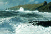
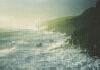
As mentioned, Mykines is a place of waves. In the winter long periods can pass where it is impossible to come by boat to the Landing-place. And the waves can be very big. Going to Mykines Holm and just passed the bridge, one sees a big concrete wall. It is a breakwater to protect the bridge form the waves and to hinder that water and stones are washed onto the bridge. Which otherwise would have been the case. The level of the bridge deck is 27 meters over the mean water level. The rail on the former bridge was bent in a gale in 1988 which also made some damage on the buildings of the Lighthouse on the Holm. Generally one can say, that all the area on the southern slopes of the Holm can be washed over by the waves when it is bad weather. And the splashes from breaking waves can reach 60 to 70 meters up in the air, as it can be calculated on pictures of the breaking waves on the Holm.Examples of this can be seen on the these pictures. Click on a picture to see an enlarged version.
|
On this picture the top of the spray of the breaker in the middle of the picture is about 50 meters high. The bridge deck is in 27 meters hight, Pikarsdrangur out left is 32 meters high and the storehouse on the Holm is placed in about 50 meters hight. |
|
On this picture the top of the spray of the breaker in the middle of the picture is about 70 meters up in the air. The altitudes are as mentioned above and the Lightmasterhouse is placed around 100 meters hight. The Lightmasterhouse is lying a little further out on the Holm. |
Click here to see many more pictures of waves, surfs and breakers from Mykines: Pictures of breakers
Mykines isolated
Before the helicopter service was established, Mykines could be isolated from the rest of the Faroes for long periods of time. The longest known period was 72 days for many years ago. But as close to our time as one winter in the 1980'ies, there was a period of 68 days in which Mykines was isolated.This is not the case anymore because the helicopter service of Mykines all the year around. The Helicopter service is much more regularly than the transport by boat in former time ever has been. But even with the helicopter service Mykines can be isolated. For some years ago the helicopter was not able to land on Mykines for 10 days in the middle of the winter because of bad weather. Especially when the wind comes from northernly directions, it can be very turbulent in the village and at the heliport.
Weather statistics for Mykines
The weather on Mykines has been recorded carefully for many years. But with changing parameters. When the Lighthouse on Mykines Holm was manned they measured force of the wind, temperature, dew point and humidity. For some periods registrations of aurora borealis, northern lights, were performed for the University in Copenhagen.There is now an automatic weather station on the Holm. It measures wind, blows of wind when these are more then 5 meters per second faster than the average. There is also measured temperature, maximum and minimum temperature in the foregoing 12 hours, humidity and atmospheric pressure. These values are recorded 8 times a day and can be seen on the homepage of The Danish Meteorological Office.
During the Second World War the amount of rain was recorded on Mykines and they showed an average rainfall between 736 and 967 millimeters, which is less than measured on other Faroese localities. In the same period between 2252 and 3232 millimeters of rain was recorded at Strond north of Klaksvik.
Wind, gales and hurricanes on Mykines
That the wind is blowing on Mykines, especially in the winter, everyone listening to the meteorological report for the Faroes will be aware. Often it is the measurements from Mykines Holm, which tells about the strongest winds. But is must be mentioned, that the measurements of the wind on Mykines are made at a very exposed place, the top of the Lighthouse which is around 125 meters above sea level and even more than the 10 meters above the surface of the land of the Holm. which otherwise is the standard for such measurements. But on the other hand, the wind measured is the wind that is there at that spot, though the wind closer to the the sea level and farther out at sea is less than measured at the Holm and also is more even, than the wind measured and experienced on the Holm and in the village. Mykines is indeed a very stormy place.Read the description of a hurricane on Mykines (and The Faroes) the 31. of January 2008 on the page Latest News from Mykines.
Weather extremes for Mykines
Mykines has some records for The Faroes.2. April 1968 the lowest temperature for April on the Faroes, minus 10 degrees centigrade, was measured. The coldest temperature ever recorded on the Faroes is minus12,3 degrees centigrade and recorded at Vága Airport the 4. of Marts 2001.
The highest speed of wind measured on the Faroes is 50 meters / second (180 km/t) recorded at the Lighthouse on the Holm both on the 7. of Marts 1997 and the 15. of January 1999. The same day in Marts 1997 the worst blow of wind was measured to 66,9 meters / second (240 km/t). Normally gale is 12 Beaufort, which is more than 32,7 meters / second. Extrapolating the Beaufort scale, the wind measured on the Holm would be around 18 on the Beaufort scale. This is not a number normally used on this scale, which is a closed scale in contrast to meters / second, which is an open scale without any end. But this comparison between these scales can tell a little about the weather on Mykines in the winter.
But wind is not only wind. It can be very different in the village depending of the direction from which it is blowing. In some directions the village is lying in lee even at a full gale at the Holm. In the village the worst direction is from north east. Coming form that direction the wind is very turbulent and very uneven coming in mighty and frightening blows.
It can be that bad, that the people of Mykines has been forced to stay the night over at other people they have been visiting, because is can be difficult to find ones feet and hazardous to be out of door, when is most violent.